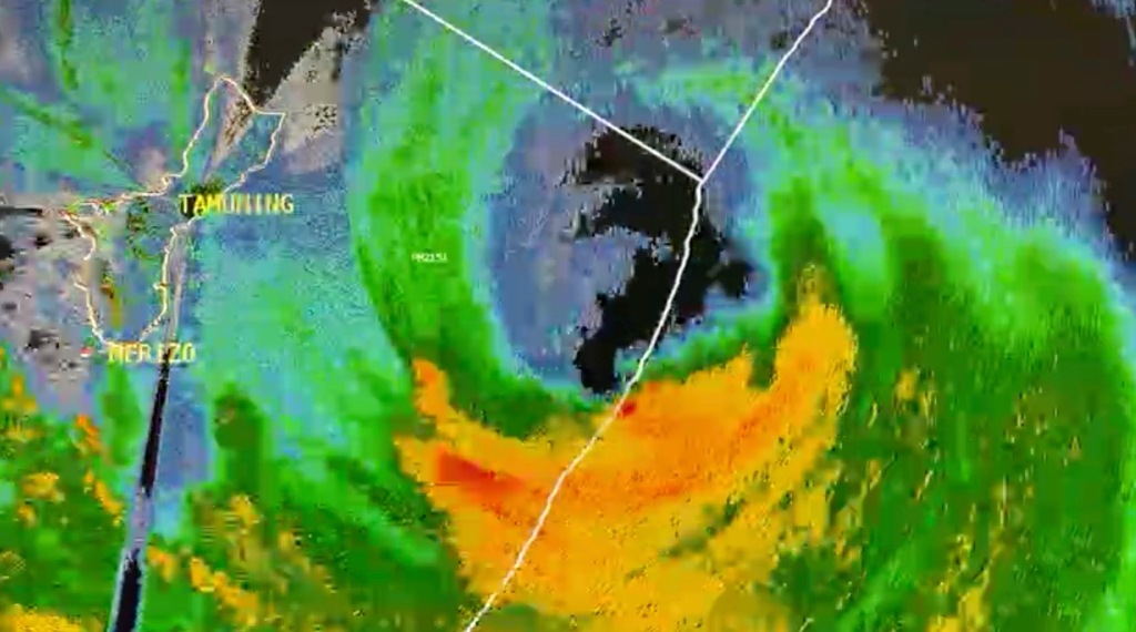
Typhoon Mawar impacting Guam as strongest storm in at least 2 decades
Residents of the U.S. territory of Guam in the Western Pacific Ocean have been ordered to evacuate low-lying areas and seek shelter in reinforced concrete structures as the island finishes preparations for a possible direct hit in what would likely be the strongest storm to impact the area in more than 20 years.
Typhoon Warnings remain in effect for Guam and Rota as Typhoon Mawar, equivalent to a Category 4 hurricane, approaches the island territory, home to more than 172,000 people, including U.S. military personnel.
The National Weather Service (NWS) office in Guam didn’t mince words when it came to providing potentially life-saving updates to those on the island.
“We are looking at the high potential for a direct hit and passage of a super typhoon on Guam,” the National Weather Service said in an update on Facebook. “This would be the first time in many years. This will be a benchmark storm that many folks on this island have not yet experienced.”
The event could be the first landfall of a significant typhoon since 2002’s Super Typhoon Pongsona.

In the most recent update, Typhoon Mawar had maximum sustained winds of 140 mph, or the equivalent of a Category 4 hurricane.
The FOX Forecast Center said the combination of an eye-wall replacement cycle and some dry air helped weaken the cyclone from its Super Typhoon status before landfall.
As the storm continues to reorganize on its approach to Guam, Typhoon Mawar is expected to bring a trio of threats – winds equivalent in strength to a major hurricane, torrential rainfall and a life-threatening storm surge.
Forecasters said a storm surge of 6 to 10 feet above the normal high tide is expected as Mawar moves closer.
However, the NWS warned that a storm surge of 20 to 25 feet is expected for the most vulnerable storm surge prone areas near the eye wall, just north of Typhoon Mawar’s eye.
The island has already experienced tropical storm-force winds (39-plus mph), and the NWS warned that those winds will only continue to get stronger and more dangerous as the situation unfolds.
“President Biden granted the emergency declarations today for both the Commonwealth of the Northern Mariana Islands and Guam ahead of Typhoon Mawar. What this means is that it unlocks the ability of the agency to supplement territorial and local responses in efforts to help save lives, protect property, public health and safety of. More importantly, it allows us to position ourselves to deal with was predicted to be a catastrophic category four or five like storm with intense damaging winds of 160 miles an hour and life-threatening storm surges across the island,” said Sherman Gillums Jr., a FEMA official.
Read the full article Here


