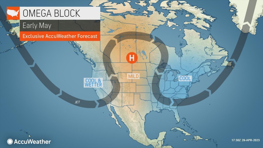
‘Omega block’ storms expected across the country this week
The U.S. is in store for a weather pattern that won’t vary much in the week ahead, with the FOX Forecast Center anticipating what is known as an “Omega block” to dominate.
An Omega block is simply a pattern where a ridge of high pressure is sandwiched in between dips in the jet stream, where areas of low pressure are usually found.
“So there’s not a lot of movement across the country, and what happens here is we’re kind of stuck,” FOX Weather meteorologist Jane Minar said. “So if you’re stuck under the low, you’re stuck under some cooler temperatures, much more in the way of cloud cover, also much more in the way of some storms.”
This pattern will mean parts of the East and West coasts will remain rather stormy and cool while the central US has time to dry out and warm up.
Usually, during this weather pattern, significant severe weather outbreaks tend to be uncommon because the dynamics are not in place for developing areas of low pressure to take advantage of needed ingredients.
Northeast rainy, cloudy pattern
The FOX Forecast Center expects quite a bit of rain from the Great Lakes to the Northeast. Between 1 and 3 inches of rainfall, with locally higher amounts, is possible over the next few days.
Due to the drier-than-average start to 2023, many communities will likely welcome the rain as flooding concerns will not be significant.
The FOX Forecast Center said the rain and increased cloud cover will keep temperatures cooler than they should be during the last month of meteorological spring.
For example, Pittsburgh typically sees highs in the upper 60s to 70 degrees in early May, but with the unsettled weather, daytime temperatures will be kept in the 40s and 50s to start the workweek.
Upper Midwest, Plains dry out
The continued melting of a significant snowpack has sent more than 100 water level gauges near or above flood stage.
The flooding is impacting major waterways such as the Mississippi, Minnesota, Red and James rivers.
Under a ridge of high pressure, chances of any significant precipitation will be greatly reduced as fair weather takes control.
The lack of rainfall will aid in some rivers cresting and slowly coming off seasonal highs.
The FOX Forecast Center expects a lack of cloud cover will also mean a warmup for some communities.
Minneapolis-St. Paul usually sees daytime highs in the mid-60s this time of year, but average readings will be replaced with temperatures that are closer to 70 degrees this week.
The warm dome of air is even more impressive in the northern Plains and Rockies.
According to climatological data, Billings, Montana, should only reach the lower 60s in early May, but temperatures are expected to be closer to 80 degrees in the week ahead.

West Coast storminess
Off-and-on cloud cover and rain associated with the West Coast dip in the jet stream will keep most of the region unsettled for the foreseeable future.
The FOX Forecast Center expects precipitation amounts to be light compared to the atmospheric river events that impacted millions during the winter.
The higher elevations will be the recipients of the highest amounts of precipitation, with snow possible in the Sierra Nevada and Cascades.
The precipitation is likely not welcome news to some in the West enduring flooding from the melting of a historic snowfall season. Flooding has even led to extensive closures at Yosemite National Park, and Flood Watches extend from California through Nevada and Idaho.
Early indications suggest the Omega block pattern has a chance to break down beginning next weekend and as the calendar approaches mid-May.
Read the full article Here


