August storm to trigger severe weather across Midwest and Northeast
The FOX Forecast Center is tracking a potent storm system that has the potential of producing rounds of showers and thunderstorms across most of the northern tier of the country over the weekend and during the start of the upcoming workweek.
The combination of a southerly flow and moist, unstable air will lead to rounds of rains kicking off ahead of an eastward-advancing cold front.
NOAA’s Storm Prediction Center placed a region covering 3 million roughly along the Kansas-Oklahoma border in a level 3 out of 5 threat on its severe thunderstorm risk category scale. Cities in this zone include Wichita, Kansas and Tulsa, Oklahoma though this heightened threat also covers parts of southeastern Colorado, the northern Texas Panhandle, and a sliver of southwestern Missouri.
Those in that region will likely see wind gusts in excess of 75 mph and at least golf-ball-sized hail with any severe thunderstorms.
Due to the threat, Severe Thunderstorm Watches were issued for more than half a dozen states from Colorado to Tennessee and Mississippi.
The thunderstorm watches include the Denver metro and Memphis, Tennessee.
Additionally, a Tornado Watch has been issued for parts of the Dakotas, western Iowa and southwest Minnesota until 10 p.m.
The Tornado Watch does include Sioux City, Iowa, and is in effect for nearly a million people.
Tornadoes already reported in Colorado
Some of the first thunderstorms that developed on Saturday afternoon produced tornadoes in Colorado and Iowa.
The SPC received at least half a dozen witness reports from the two states of twisters briefly on the ground.
Vanessa Ribeiro-Lawton took photos of one the tornadoes around Black Forest, Colorado, north of Colorado Springs.
There were no initial reports of widespread damage in any of the areas impacted by the tornadoes.

Sunday severe weather threat: Ohio and Tennessee Valley
The potent storm system is expected to continue to strengthen as it treks eastward across the Mississippi Valley on Sunday and into the Ohio and Tennessee Valleys.
The SPC has highlighted communities from central Illinois and eastern Missouri to nearly all of Tennessee and Kentucky for seeing the highest risk of severe storms, giving them a level 2 threat so far.
Forecasters warn all severe weather hazards will be possible, but damaging wind gusts and heavy rainfall will be the primary concerns.
St. Louis, Nashville and Cincinnati are all included in the heightened threat zone as storms work from west to east across the region.
For Indianapolis and Louisville areas, it’s a second day under a severe weather threat coming off the expected severe weather Saturday night.
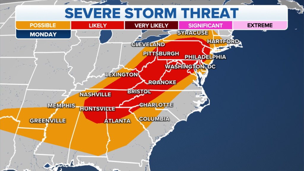
Monday severe weather threat: Northeast
Showers and thunderstorms are expected to push out of the Ohio Valley and into communities along the Appalachians and Northeast to start the workweek.
The severity of the storms will depend on timing and if enough daytime heating is present to aid in development.
According to the FOX Forecast Center, heavy rainfall and damaging wind gusts are considered to be the main threats.
Communities that are expected to see showers and thunderstorms include Pittsburgh; Binghamton, New York; Philadelphia, Washington, Charleston, West Virginia; and Nashville.
Much of the storm system’s energy is expected to lift northeastward into Canada after Monday, leaving diminished chances of severe weather in the Northeast on Tuesday.
Read the full article Here


