Dangerous snow squalls expected near Great Lakes, Northeast
As the calendar pushes deeper into spring, signs of winter will still be prevalent across the eastern Great Lakes and interior Northeast on Wednesday as a frontal boundary brings the risk of intense bursts of snow, wind and a drastic temperature drop.
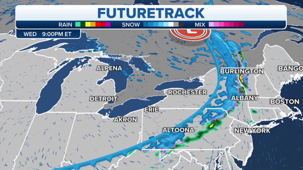
A front’s sharp dividing line will drop by 10 to 30 degrees between 5 p.m. ET and 10 p.m. ET, and cause a flash freeze in some areas. It will also bring with it the threat of snow squalls.
Snow squalls are sudden bursts of precipitation typically lasting less than an hour, but they can produce heavy snowfall rates and drop visibilities.
On Wednesday, communities under threat from these conditions stretch from the eastern Great Lakes through the interior Northeast and New England. Cities such as Cleveland; Buffalo, New York; State College, Pennsylvania; and Burlington, Vermont, could see brief rounds of snow with poor visibilities.
Snow squalls threaten Wednesday evening commutes
“This is going to be a quick-moving system. So what’s going to happen? Visibility will be reduced rather quickly as we look towards your Wednesday evening, arriving through western New York, Buffalo, down through Cleveland,” said FOX Weather meteorologist Brigit Mahoney.
Snowfall rates will vary drastically by city, and forecast models show the overall accumulations will not amount to much or cut down on season snowfall deficits.
These snow squalls pose the biggest threat to travelers, especially during the evening rush hour, when roads could become slick during whiteout conditions.


“We likely are going to see some snow squall warnings in effect. It is a very intense, short-lived burst of heavy snow that can be immediately blinding. You could be driving on the interstate, things look just fine one minute, and then the next second, that’s where you see the blinding conditions,” said Mahoney.
Forecast models show wind gusts could reach 30-50 mph before tapering off in the late evening.
Northerly winds are also expected to help usher in some colder-than-normal air that will only last for a day or so.
By Friday, highs area-wide will reach above-average levels, ahead of another storm system that could produce more cold rain and snow over the weekend.
Read the full article Here


