
Hurricane Fiona could reach Category 4, nears Turks and Caicos
At least three people are dead across Puerto Rico and the Dominican Republic as Hurricane Fiona intensified into the Atlantic’s first major hurricane of the season overnight near the Turks and Caicos Islands, according to reports.
Hurricane Fiona has been steadily strengthening and could reach Category 4 intensity by early Wednesday as it heads in the direction of Bermuda through the end of the week.
Even with Fiona pulling farther away from the Caribbean, its outer bands will continue to produce heavy rain over coastal and eastern sections of the Dominican Republic and isolated portions of Puerto Rico through Tuesday. The FOX Forecast Center warns that these rains could produce additional localized life-threatening flash flooding.
Fiona made two landfalls as a Category 1 hurricane, the first one Sunday afternoon along the extreme southwestern coast of Puerto Rico and the second one early Monday morning in the eastern Dominican Republic.
In Puerto Rico, the city of Ponce clocked a 103-mph wind gust, while in the Dominican Republic, a gust of 98 mph was recorded in Samana at El Catey International Airport. The high winds plunged all of Puerto Rico into a blackout on Sunday as catastrophic flooding unfolded across the U.S. territory.
Where is Hurricane Fiona?
As of early Tuesday morning, Fiona was a Category 3 hurricane centered near Grand Turk Island and was moving north-northwestward at 10 mph.
Any hurricane that is rated Category 3 or higher on the Saffir-Simpson Hurricane Wind Scale is defined as a major hurricane.
Where are watches and warnings in effect?
A Hurricane Warning has been issued for the Turks and Caicos. A Hurricane Warning means sustained winds of at least 74 mph are expected.
Tropical Storm Warnings have been issued for the southeastern Bahamas. A Tropical Storm Warning means sustained winds between 39 and 73 mph are expected.
What is the forecast for Hurricane Fiona?
According to the FOX Forecast Center, the center of Hurricane Fiona will move near Grand Turk and the other eastern Turks and Caicos through Tuesday morning.
Hurricane-force winds (74-plus mph) and heavy rain around the center of Hurricane Fiona will impact the Turks and Caicos through Tuesday afternoon with a continued risk of life-threatening flooding. Tropical-storm-force winds (39-plus mph) and heavy rain from Fiona’s outer rainbands should also begin to spread over the southeastern Bahamas later Tuesday morning and last into Tuesday night.
Hurricane Fiona will continue to strengthen over the next couple of days and is now expected to become a Category 4 hurricane by early Wednesday. It will move toward the north-northwest through Tuesday before making a northward turn Tuesday night or Wednesday.
Hurricane Fiona could pass very close to Bermuda by Thursday night or Friday morning, potentially as a Category 4 hurricane.
Fiona’s high winds will also send large waves toward the U.S. East Coast toward the end of the week, increasing the risk of life-threatening rip currents along the Atlantic beaches.
How much more rain will Hurricane Fiona produce?
An additional 4 to 8 inches of rain is expected across the Turks and Caicos Islands as Hurricane Fiona impacts the British overseas territory, posing a continued risk of life-threatening flooding.
Farther north, the southeastern Bahamas are forecast to pick up 1 to 4 inches of rain.
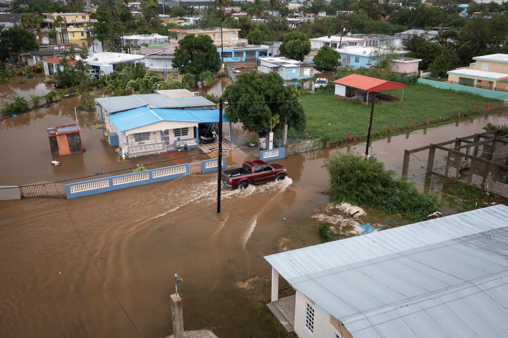
Additional rainfall amounts between 1 and 4 inches are also predicted across Puerto Rico and the Dominican Republic, where additional localized life-threatening flash flooding.
Flood Watches remain in effect for all of Puerto Rico and the U.S. Virgin Islands through Tuesday evening.
2022 Atlantic hurricane season off to a slow start
Early to mid-September is the time of the season when sea-surface temperatures are the warmest, upper-level winds relax, and drier air is typically not widespread.
Unlike recent active years, dry air has been more dominant than usual across the eastern parts of the Atlantic Basin, which has stunted the organization and development of tropical cyclones.
The Atlantic Hurricane Season is off to a slow start with only six systems named since June 1. FOX Weather’s Brandy Campbell spoke to experts about the combination of the Saharan dust, dry air, and hostile winds that are keeping the season quiet, surprising many.
August ended without seeing a single tropical cyclone in the Atlantic Basin for only the second time in the satellite era.
During an average year, nine named storms and four hurricanes have typically already formed by now, but so far in 2022, the tally stands at just six named storms and three hurricanes.
Read the full article Here
