Massive coast-to-coast winter storm to pummel millions with blizzard conditions, significant icing
A major and disruptive winter storm could go down in the history books for parts of the U.S. as it impacts millions of people with heavy snow, blizzard conditions and significant icing.
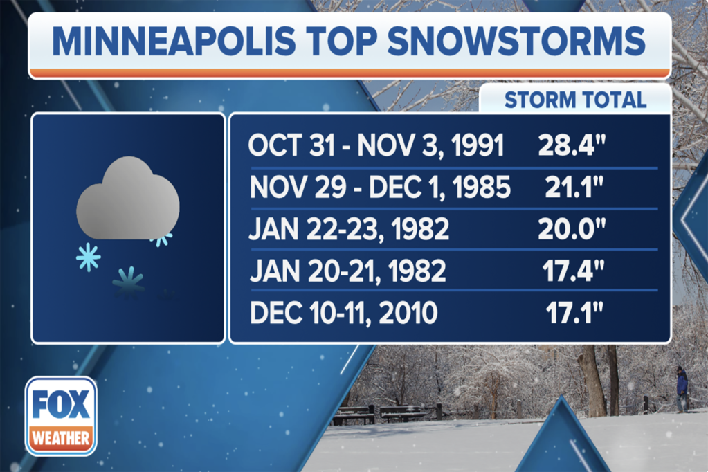
This coast-to-coast winter storm could be among the top snowstorms to ever strike Minneapolis, with the Twin Cities potentially seeing up to 2 feet of snow by the time the massive storm system exits the region.
While snow and wind started impacting the region Tuesday, significant ice could also lead to major problems from Iowa to New York state as we move through the workweek.
Let’s break down each day and threat to better understand this complex winter storm.
Winter weather alerts
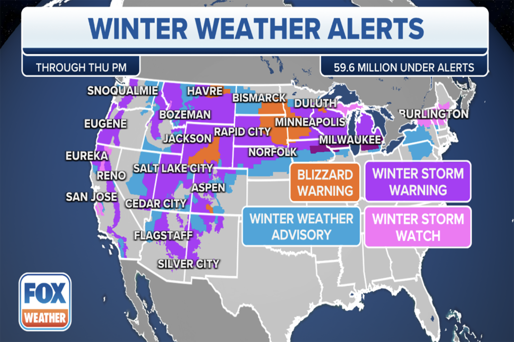
More than 60 million Americans are now under some sort of winter weather alert, and that number will grow as the week continues.
Blizzard Warnings have been issued for parts of five states in the Rockies, northern Plains and Upper Midwest, including, Wyoming, Colorado, South Dakota, Minnesota and Iowa.
Elsewhere, a variety of Winter Storm Warnings, Winter Storm Watches and Winter Weather Advisories stretch from the West Coast to the Upper Midwest, Great Lakes, upstate New York and northern New England.
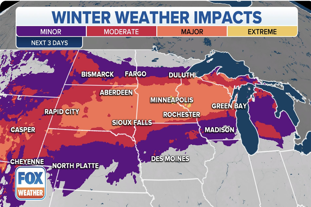
NOAA’s Weather Prediction Center works around the clock to update the agency’s Winter Storm Severity Index (WSSI), which highlights the severity of the expected impacts from approaching storm systems.
The WSSI is a tool meant to aid in decision-making when snow, ice, wind and freezing temperatures could be disruptive.
Over the next three days, “extreme” impacts – the highest category in the WSSI – from this coast-to-coast winter storm are expected across south-central Minnesota, including the Minneapolis-St. Paul metro area.
“Moderate” to “major” impacts can be expected elsewhere across the northern Plains and Upper Midwest.
Timing
The winter storm will persist for multiple days in some areas along its cross-country journey. Here’s a general day-by-day breakdown of the timing.
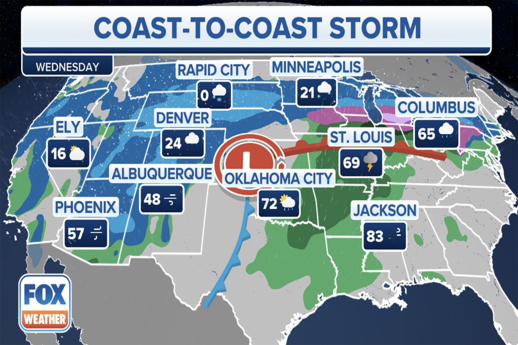
Wednesday-Wednesday night: More people will be affected by the winter storm as we head into Wednesday. Snow will pick up in intensity across the Rockies, northern Plains and Upper Midwest, and it will overlap with increasingly strong winds to spawn blizzard conditions in some areas. Farther east, snow will develop across the interior Northeast and parts of New England. On the southern fringes of the snowfall, a band of sleet and freezing rain will lead to significant ice accretions from the mid-Missouri Valley to the southern Great Lakes and parts of the interior Northeast.
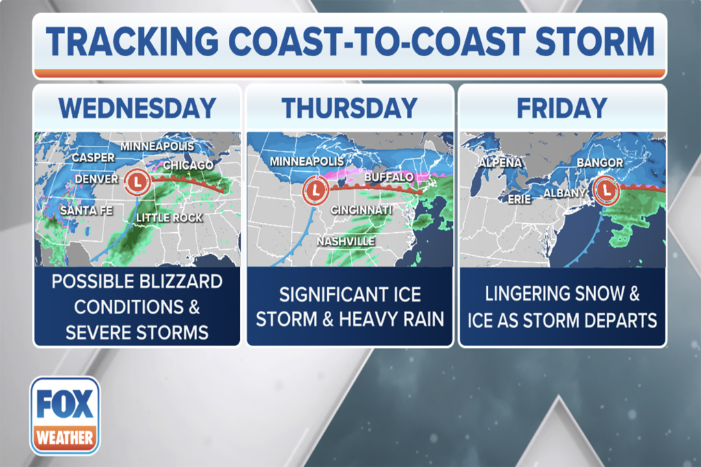
Thursday-Thursday night: A mix of snow, sleet and freezing rain will linger across portions of upstate New York and New England before tapering off by early Friday. Back to the west, snow will come to an end Thursday afternoon across the Upper Midwest and western Great Lakes.
How much snow is expected?
According to the FOX Forecast Center, there is growing confidence that a foot or more of snow could fall across portions of the northern Plains, Upper Midwest and northern Great Lakes, including the possibility of blizzard conditions.
The Minneapolis area could see up to 2 feet of snow from this winter storm, making it among the top snowstorms in the city’s history and its heaviest snowstorm since December 2010.
At least a half-foot of snow is likely across the Rockies, Intermountain West and parts of the Four Corners region.
In the Northeast, 6-plus inches of snow is expected across northern portions of upstate New York and northern New England, with lower snowfall amounts south of the New York State Thruway and Massachusetts Turnpike (Interstate 90) because of the mixing with sleet and freezing rain.
Of course, any changes to the storm track this week could affect snow and ice totals. Be sure to download the free FOX Weather app and enable notifications to be alerted to any changes in the forecast.
High winds could lead to blizzard conditions in northern Plains, Upper Midwest
Regardless of the amount of snow that falls, high winds could lead to blizzard conditions in the northern Plains and Upper Midwest, making travel nearly impossible due to near-zero visibility from blowing and drifting snow.
Anyone living or working in the dozens of states affected by this storm should expect road closures, shuttered schools and significant impacts on air travel.
The combination of the high winds and the weight of the snow could also knock down tree limbs and lead to scattered power outages in the region.
How much ice is expected?
As the warmer air overrides the cold air along a front, a relatively narrow corridor of freezing rain and sleet is expected through Thursday.
Major disruptions because of the ice are possible from Iowa to upstate New York.
The greatest threat for up to a quarter-inch of ice accretion will stretch from southern Lower Michigan to western New York, including the cities of Detroit and Buffalo.
Between the combination of ice, snow and wind, not only will travel be a nightmare, but power outages will also become a concern for millions of Americans from South Dakota and Minnesota to New York and Pennsylvania.
Read the full article Here


