
Peak hurricane season nears in Atlantic basin with several tropical systems
The Atlantic Ocean basin remains quite busy for tropical systems, and with atmospheric conditions becoming more favorable for tropical development, the coming weeks may bring even more activity.
Tropical Storm Franklin is making landfall along the southern shores of the Dominican Republic Wednesday morning, according to the National Hurricane Center, and two other tropical disturbances are swirling farther out in the Atlantic.
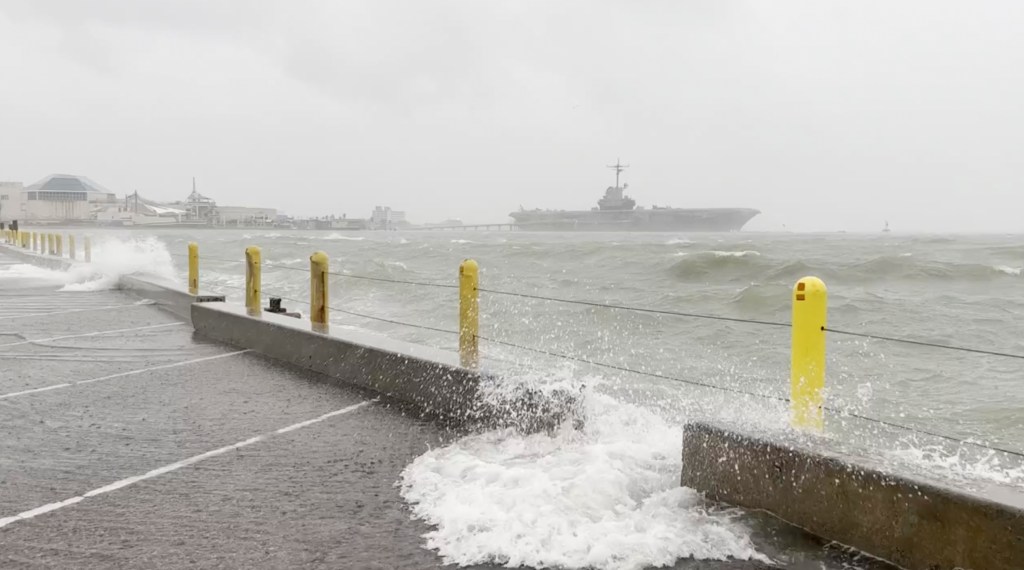
Additionally, Tropical Storm Harold caused heavy rain and flooding in Texas on Tuesday, and its remnants are now moving towards a Desert Southwest region still wringing out from the remnants of Tropical Storm Hilary earlier this week.
All this comes just before the peak of the Atlantic hurricane season, which arrives on Sept. 10.
The basin sees the most tropical activity between mid-August and mid-October.
Tropical Storm Franklin making landfall in Dominican Republic
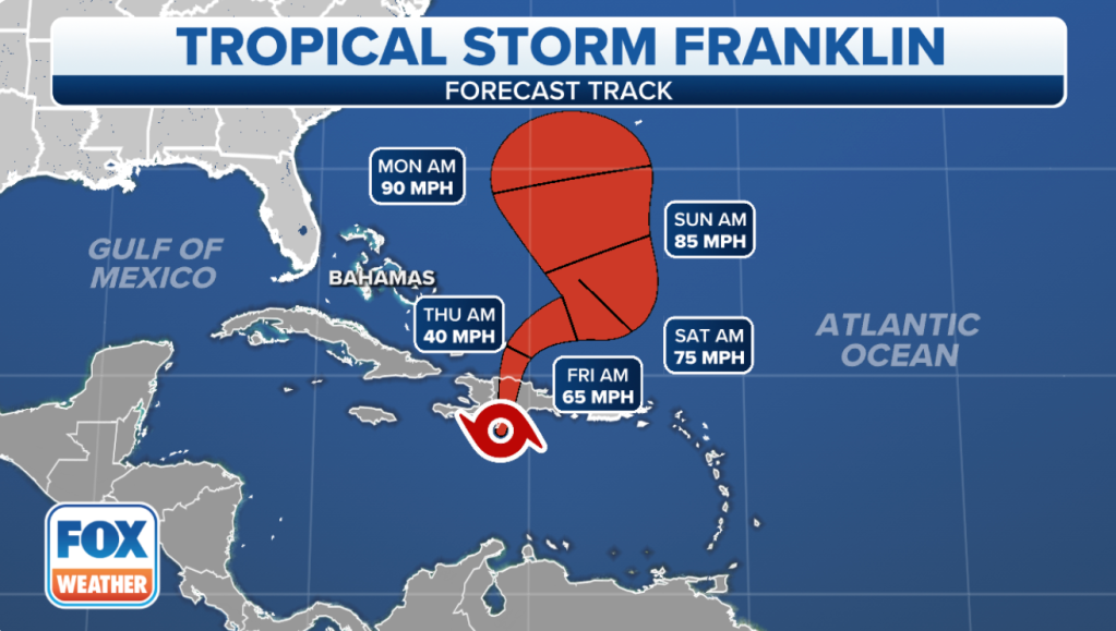
Tropical Storm Franklin reached the Dominican Republic shores Wednesday morning, nearing landfall at 8 a.m. ET and lashing Hispaniola and Puerto Rico with heavy rain and 50 mph wind through the day into Thursday.
Franklin is heading north at 10 mph and sits about 105 miles southwest of Santo Domingo, Dominican Republic.
“Life-threatening” flash flooding is possible in the Dominican Republic as forecasted rain totals reach 10-15 inches in some spots, the NHC reports.

Tropical Storm Warnings remain in effect for the coasts of the Dominican Republic and Haiti, plus the islands of Turks and Caicos.
Franklin has maximum sustained winds near 50 mph with higher gusts.
Puerto Rico, which is outside the tropical advisories, could see 2 to 4 inches of rain and up to 6 inches locally through the middle of the week.
Other areas of interest worth monitoring
Odds are increasing that remnants of Tropical Storm Emily will redevelop as it moves northward over the subtropical central Atlantic.
The NHC now predicts a 50% chance of reforming into a tropical depression within the next two days and a 70% chance within the next week.
The NHC also predicts a low to medium chance of a tropical depression forming later this week in the eastern tropical Atlantic, near Africa, with the disturbance they’ve dubbed Invest 92L.
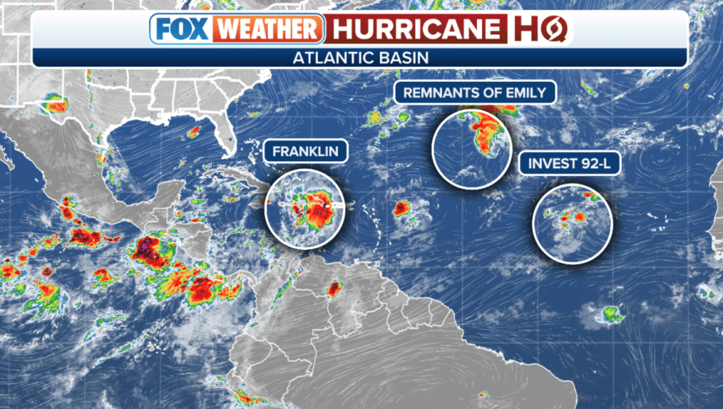
An “invest” is an NHC term used to identify areas they are investigating for possible development into a tropical depression or tropical storm within the next seven days.
With currently unfavorable conditions for development, 92L has a 10% chance of development in the next two days and a 40% chance of becoming a tropical depression over the next seven days, according to the NHC.
Tropical Depression Harold to bring rain to Southwest
Meanwhile the remnants of Tropical Storm Harold are about to give the Desert Southwest a second soaking in just a few days.
Tropical Storm Harold hit Padre Island, Texas at 9:50 a.m. CT on Tuesday, bringing heavy rains and strong winds to South Texas.
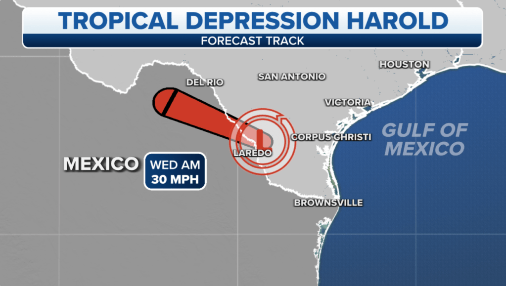
It weakened to a tropical depression after making landfall.
Currently, what’s left of the storm is 235 miles south of Midland, Texas and is moving west-northwest at 14 mph. Maximum sustained winds are 30 mph.
Read the full article Here
