
Severe storms threaten the East Coast with hail, wind, tornadoes
The final day of a multi-day severe event will encompass millions along the Eastern Seaboard on Saturday, with the threats of damaging winds, hail and even an isolated tornado.
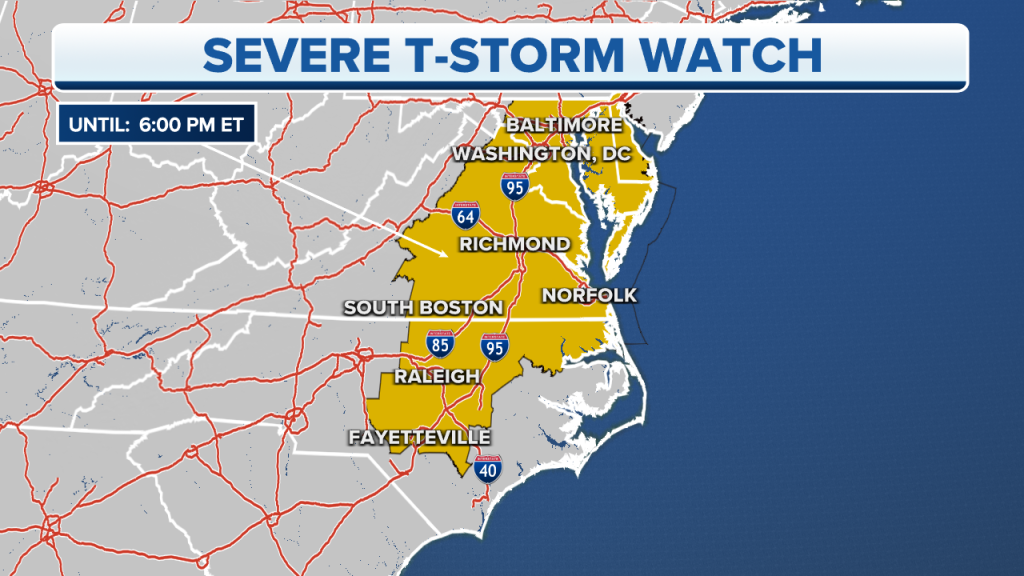
A Severe Thunderstorm Watch has been issued through 6 p.m. for the Interstate 95 corridor and runs from Baltimore to Raleigh, North Carolina.
The cold front responsible for the storms kicked off with severe weather over the Plains on Tuesday.
Less than 24 hours later, a slug of moisture helped storms develop from the Midwest to Texas and was responsible for killing at least three people in Cole, Oklahoma.
Several tornadoes struck south and east of the Oklahoma City metro Wednesday night.
The increased threat of storms on Saturday will diminish once the frontal boundary moves offshore, which is not expected to happen before sunset.
A tornado caused damage in Cole, Oklahoma, as an outbreak erupted on Wednesday.
Rain stretches from the Northeast to the Gulf Coast, but the FOX Forecast Center is watching the southern half of the line closely for the threat of strong to severe storms.
In the strongest of storms, hail, gusty winds and an isolated tornado threat is possible.
Meteorologists caution any storm is capable of producing heavy rainfall and plenty of lightning, and the national radar is picking up on plenty of both over the eastern third of the country.
Within the yellow watch box, the SPC warns hail up to 1 inch in diameter and winds gusts to 70 mph are possible.
Severe thunderstorms will be possible on Saturday from Philadelphia and southeastern Pennsylvania, through Maryland and Washington, DC into Virginia’s Tidewater area into the beaches of North and South Carolina.
The FOX Forecast Center said it will be monitoring this region for the risk of hail and 60-plus-mph wind gusts during the afternoon hours.
The tornado threat is not zero but is not the greatest risk for communities on Saturday.
“This is going to mostly be for the afternoon into the evening hours. Large hail could be a threat and damaging winds will also be a possibility. So, let’s not be surprised if we do see some hail associated with this storm. And this does include the Outer Banks of North Carolina,” said FOX Weather meteorologist Stephen Morgan.
Read the full article Here
